Ben Chonzie
"Mossy Hill"
Ben Chonzie, also known as Ben-y-Hone or in Gaelic Beinn a’ Chòinnich, stands at an elevation of 931 meters (3,054 feet) in the Breadalbane region of the Scottish Highlands.
We have 2 routes to climb this Munro, details below.
The route from Glen Lednock is a popular way to climb Ben Chonzie for beginner Munro bagger.
Ben Chonzie From Loch Turret

Loch Turret Route Length: 10.5 miles Total Ascent: 2700 ft Surface: Rough/Paths/Grass/Bog
Difficulty: Moderate/Hard
Average Walking Time: 6:30 h
Route starts at the Loch Turret Car Park, Crieff.
Google maps directions to the route start can be found HERE
Loch Turret Route
360° Virtual Tour
The virtual tour of Ben Chonzie below is from Loch Turret travelling in a clockwise direction.
Click on the round 360 logo in the tour window below to move forward through the Munro route tour. Pan Around using your mouse or finger. Press the Map - Show/Hide button to see where you are on the route. The red photo location marker within the map points it's radar in the direction of the photos view. The compass within the tour window lets you know the direction of view and travel. If possible view on a VR Headset to feel like your there!
Maps - View - Print - GPX File Download
All routes on 360munros.co.uk are SUMMER Munro Bagging Routes.
Winter Munro routes with Ice/Snow can be extremely challenging and dangerous.
The downloading and use of GPX files or printing of maps from 360munros.co.uk by individuals or groups as a navigational aid is entirely at the risk of the user.
Ben Chonzie From Glen Lednock
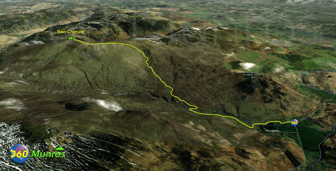
Ben Chonzie is regarded as one of the “easier” Munros to climb from the Glen Lednock side. Although this is true on a fine clear summers day, it’s been proven by novice hill walkers that it’s very easy to get lost on this hill under low visibility. If your caught up this hill in low visibility, good navigational skills will be required.
Begin your ascent from Glen Lednock, just north of the village of Comrie. Park at the end of the single-track road (marked as Coishavachan on the map)
Route Length: 8 miles Total Ascent: 2350 ft Surface: Rough/Paths/Grass
Difficulty: Moderate
Average Walking Time: 4:30 h
Route starts just south of Invergeldie, Crieff PH6 2LY.
Google maps directions to the route start can be found HERE
Ben Chonzie From Glen Lednock
360° Virtual Tour
Maps - View - Print - GPX File Download
All routes on 360munros.co.uk are SUMMER Munro Bagging Routes.
Winter Munro routes with Ice/Snow can be extremely challenging and dangerous.
The downloading and use of GPX files or printing of maps from 360munros.co.uk by individuals or groups as a navigational aid is entirely at the risk of the user.
3D Model of Ben Chonzie
3D model loading…… Internet speed dependant.
Click on the 3D model to move around / zoom in out.
