Fannich Munros
The Fannich Munros are a group of nine mountains over 3,000 feet (914.4 meters) located in the Fannich Forest range in the Scottish Highlands, south of Ullapool and between Loch Fannich and the A835 Ullapool road. These peaks are popular among hillwalkers and Munro baggers for their scenic ridges, remote feel, and relatively gentle slopes
5 Western Fannichs
The Western Fannich Munros – a group of five majestic mountains located south of Loch a’ Bhraoin in the Scottish Highlands.

A’Chailleach – ‘Old Woman’ – Altitude: 997m
Sgurr Breac – ‘Speckled Peak’ – Altitude: 999m
Sgurr na Each – ‘Peak of the Horses’ – Altitude: 923m
Sgurr nan Clach Geala – ‘Peak of the White Stones’ – Altitude: 1093m
Meall na Chrasgaidh –‘Hill Of The Crossing’ – Altitude: 934m
Route Length: 15 miles Total Ascent: 6000 ft Surface: Grass/paths/pathless
Difficulty: Very Hard
Average Walking Time: 15:00 h
Route starts at the end of Loch a’ Bhraoin.
Google maps directions to the route start can be found HERE
5 Western Fannichs
360° Virtual Tour
Maps - View - Print - GPX File Download
All routes on 360munros.co.uk are SUMMER Munro Bagging Routes.
Winter Munro routes with Ice/Snow can be extremely challenging and dangerous.
The downloading and use of GPX files or printing of maps from 360munros.co.uk by individuals or groups as a navigational aid is entirely at the risk of the user.
4 Eastern Fannichs

Beinn Liath Mhor – ‘Big Grey Hill of Fannaich’ – Altitude: 954m
Sgurr Mor – ‘Big Peak’ – Altitude: 1110m
Meall Gorm – ‘Blue rounded hill’ – Altitude: 949m
An Coileachan – ‘The Cockerel’ – Altitude: 923m
Route Length: 16 miles Total Ascent: 4022 ft Surface: Grass/bog/paths/pathless
Difficulty: Very Hard
Average Walking Time: 9:00 h
Route starts at the end of Loch Glascarnoch.
Google maps directions to the route start can be found HERE
4 Eastern Fannichs
360° Virtual Tour
Click on the round 360 logo in the tour window below to move forward through the Munro route tour. Pan Around using your mouse or finger. Press the Map - Show/Hide button to see where you are on the route. The red photo location marker within the map points it's radar in the direction of the photos view. The compass within the tour window lets you know the direction of view and travel. If possible view on a VR Headset to feel like your there!
Maps - View - Print - GPX File Download
All routes on 360munros.co.uk are SUMMER Munro Bagging Routes.
Winter Munro routes with Ice/Snow can be extremely challenging and dangerous.
The downloading and use of GPX files or printing of maps from 360munros.co.uk by individuals or groups as a navigational aid is entirely at the risk of the user.
All 9 Fannichs
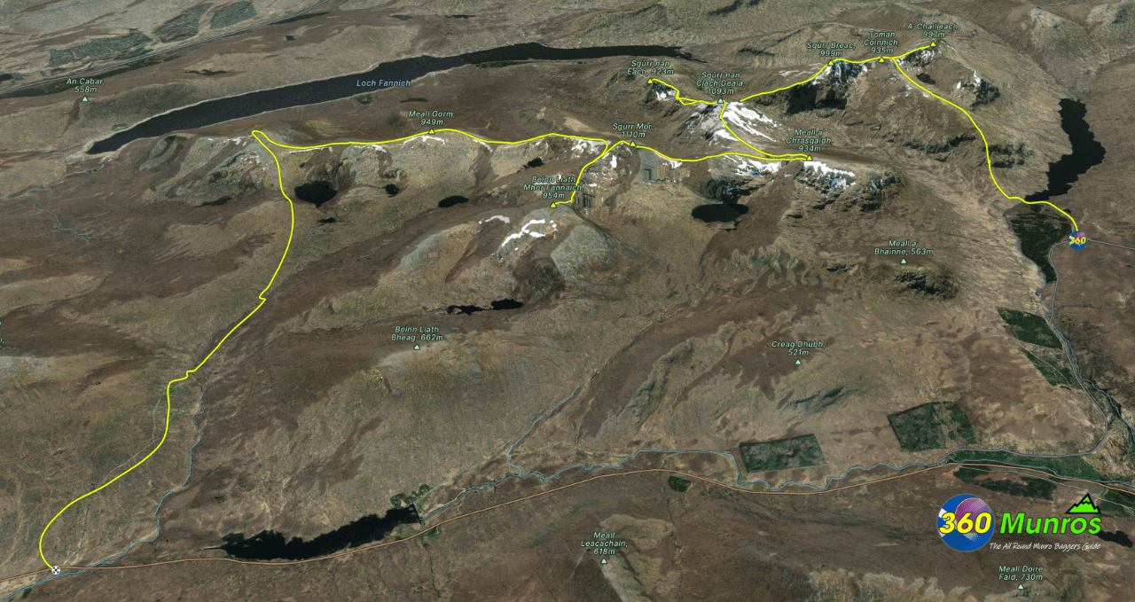
Route details with map, 3D model and GPX download of the route to the summit of these mountains in Scotland.
An Coileachan – ‘The Cockerel’ – Altitude: 923m
Meall Gorm – ‘Blue rounded hill’ – Altitude: 949m
Beinn Liath Mhor – ‘Big Grey Hill of Fannaich’ – Altitude: 954m
Sgurr Mor – ‘Big Peak’ – Altitude: 1110m
Meall na Chrasgaidh –‘Hill Of The Crossing’ – Altitude: 934m
Sgurr nan Clach Geala – ‘Peak of the White Stones’ – Altitude: 1093m
Sgurr na Each – ‘Peak of the Horses’ – Altitude: 923m
Sgurr Breac – ‘Speckled Peak’ – Altitude: 999m
A’Chailleach – ‘Old Woman’ – Altitude: 997m
Route Length: 23 miles Total Ascent: 8520 ft Surface: Grass/paths/pathless
Difficulty: Very Hard +
Average Walking Time: 15:00 h
Route starts at the end of Loch a’ Bhraoin.
Google maps directions to the route start can be found HERE
Maps - View - Print - GPX File Download
All routes on 360munros.co.uk are SUMMER Munro Bagging Routes.
Winter Munro routes with Ice/Snow can be extremely challenging and dangerous.
The downloading and use of GPX files or printing of maps from 360munros.co.uk by individuals or groups as a navigational aid is entirely at the risk of the user.
3D Model of the Fannich Munros
3D model loading…… Internet speed dependant.
Click on the 3D model to move around / zoom in out.
