Brothers Ridge
High above Glen Shiel, three Munros rise like brothers standing guard:
Aonach Meadhoin – “Middle Ridge” The central summit, a place of balance and gathering, where travellers pause between east and west.
Sgùrr a’ Bhealaich Dheirg – “Peak of the Red Pass” The highest of the trio, its name recalls a blood‑red pass. Some say it echoes the clash of steel and the spilled blood of the Battle of Glenshiel , when Jacobite clans and Spanish allies fought government troops on these very slopes.
Sàileag – “Little Heel” Modest in height but symbolically powerful, the heel marks the first stride into adventure — a foundation stone for the ridge itself.
Together, these peaks form the Brothers Ridge, a traverse that is both a Munro baggers challenge and a journey through myth and memory. To walk here is to follow in the footsteps of warriors and wanderers alike — across the middle ground, through the red pass, and onward with the heel that carries you into the Highlands beyond.
The Battle of Glenshiel, fought on 10 June 1719, unfolded across this very glen. Much of the action took place on the slopes of Sgurr na Ciste Duibhe and along the ridge beside it. Nearby Sgurr nan Spainteach—the Peak of the Spaniards—recalls the 300 Spanish marines who helped the Jacobite force and built the stone breastworks that still cling to the hillside today. Highland clans held these heights against the advancing government troops until the battle’s defeat brought the brief Jacobite rising of 1719 to an end. Yet the land remembers: Gaelic names like Bealach Dheirg, the “Red Pass,” preserve echoes of struggle, turning the Northern Ridge into a living monument where stone, story, and history intertwine.
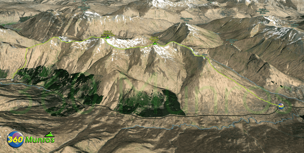
Route details with map, 3D model and GPX download of the route to the summit of these mountains in Scotland.
Munro – Aonach Meadhoin – Altitude: 1001 metres
Munro – Sgùrr a’ Bhealaich Dheirg – Altitude: 1036 metres
Munro – Sàileag – Altitude: 956 metres
Length: 6.2 miles Total Ascent: 3850 ft Surface: Rough – rock/grassy
Difficulty: Very steep climb and descent from ridge.
Average Walking Time: 4:35 h
Route starts at the Landour Bakehouse. The Cluanie Inn Glenmoriston IV63 7YW.
Google maps directions to the route start can be found HERE
Brothers Ridge
360° Virtual Tour
Click on the round 360 logo in the tour window below to move forward through the Munro route tour. Pan Around using your mouse or finger. Press the Map - Show/Hide button to see where you are on the route. The red photo location marker within the map points it's radar in the direction of the photos view. The compass within the tour window lets you know the direction of view and travel. If possible view on a VR Headset to feel like your there!
Maps - View - Print - GPX File Download
All routes on 360munros.co.uk are SUMMER Munro Bagging Routes.
Winter Munro routes with Ice/Snow can be extremely challenging and dangerous.
The downloading and use of GPX files or printing of maps from 360munros.co.uk by individuals or groups as a navigational aid is entirely at the risk of the user.
3D Model of Brothers Ridge
3D model loading…… Internet speed dependant.
The red line on the 3D model shows the route.
Click on the 3D model to move around / zoom in out.
