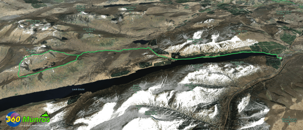
Ben Alder and Beinn Bheòil
‘Hill of Rock and Water’ - ‘Hill of the Mouth’
Route details with map, 3D model and GPX download of the route to the summit of these mountains in Scotland.
Munro – Ben Alder – Altitude: 1148 metres
Munro – Beinn Bheòil – Altitude: 1019 metres
Length: 28.7 miles Total Ascent: 4490 ft Surface: 7 mile road in/ Rough/ Pathless
Difficulty: Hard
Average Walking Time: 13:15 h
Time could be saved by cycling in and out.
Could be done along with the Aonach Beag 4
See the bottom of this page for the Ben Alder 6 route.
Route starts near Dalwhinnie Service Station – 24HR FUEL, Dalwhinnie PH19 1AF.
Google maps directions to the route start can be found HERE
Maps - View - Print - GPX File Download
All routes on 360munros.co.uk are SUMMER Munro Bagging Routes.
Winter Munro routes with Ice/Snow can be extremely challenging and dangerous.
The downloading and use of GPX files or printing of maps from 360munros.co.uk by individuals or groups as a navigational aid is entirely at the risk of the user.
3D Model of Ben Alder and Beinn Bheòil
3D model loading…… Internet speed dependant.
The red line on the 3D model shows the route.
Click on the 3D model to move around / zoom in out.
The Ben Alder 6
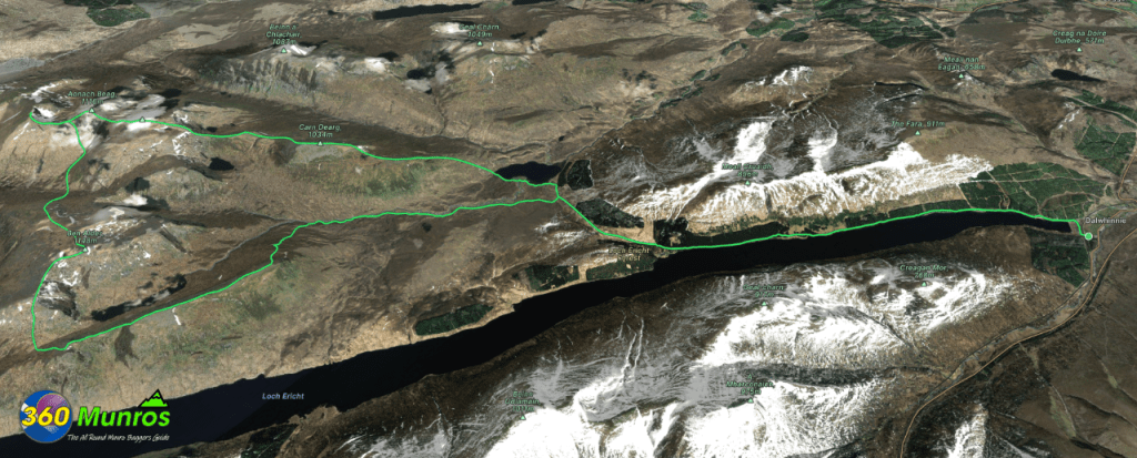
Munro – Beinn Bheòil – Altitude: 1019 metres
Munro – Ben Alder – Altitude: 1148 metres
Munro – Beinn Èibhinn – Altitude: 1102 metres
Munro – Aonach Beag – Altitude: 1116 metres
Munro – Geal Chàrn – Altitude: 1132 metres
Munro – Cairn Dearg – Altitude: 1034 metres
Length: 35 miles Total Ascent: 6850 ft Surface: 7 mile road in/ Rough/ Pathless
Difficulty: Hard
Average Walking Time: 10:30 hrs from Culra Lodge
Time could be saved by cycling in and out.
The Ben Alder 6
360° Virtual Tour
Click on the round 360 logo in the tour window below to move forward through the Munro route tour. Pan Around using your mouse or finger. Press the Map - Show/Hide button to see where you are on the route. The red photo location marker within the map points it's radar in the direction of the photos view. The compass within the tour window lets you know the direction of view and travel. If possible view on a VR Headset to feel like your there!
Maps - View - Print - GPX File Download
All routes on 360munros.co.uk are SUMMER Munro Bagging Routes.
Winter Munro routes with Ice/Snow can be extremely challenging and dangerous.
The downloading and use of GPX files or printing of maps from 360munros.co.uk by individuals or groups as a navigational aid is entirely at the risk of the user.
3D Model of the Ben Alder 6
3D model loading…… This is a large 3D model so load time dependent on Internet speed.
The red line on the 3D model shows the route.
Click on the 3D model to move around / zoom in out.
