Ben Lomond
‘Beacon Mountain’
Munro – Ben Lomond – Altitude: 974 metres
The most Southern Munro and probably one of the most climbed. Ben Lomond via its well maintained mountain path is a fairly straightforward Munro to climb and is definitely one of the easier hikes (on a nice day) for the beginner Munro Bagger.
Route details with map, 3D model and GPX download of the route to the summit of this mountain in Scotland.
Ben Lomond Via the Mountain Path
Definitely the easiest and most popular way to climb Ben Lomond is via the mountain path route.
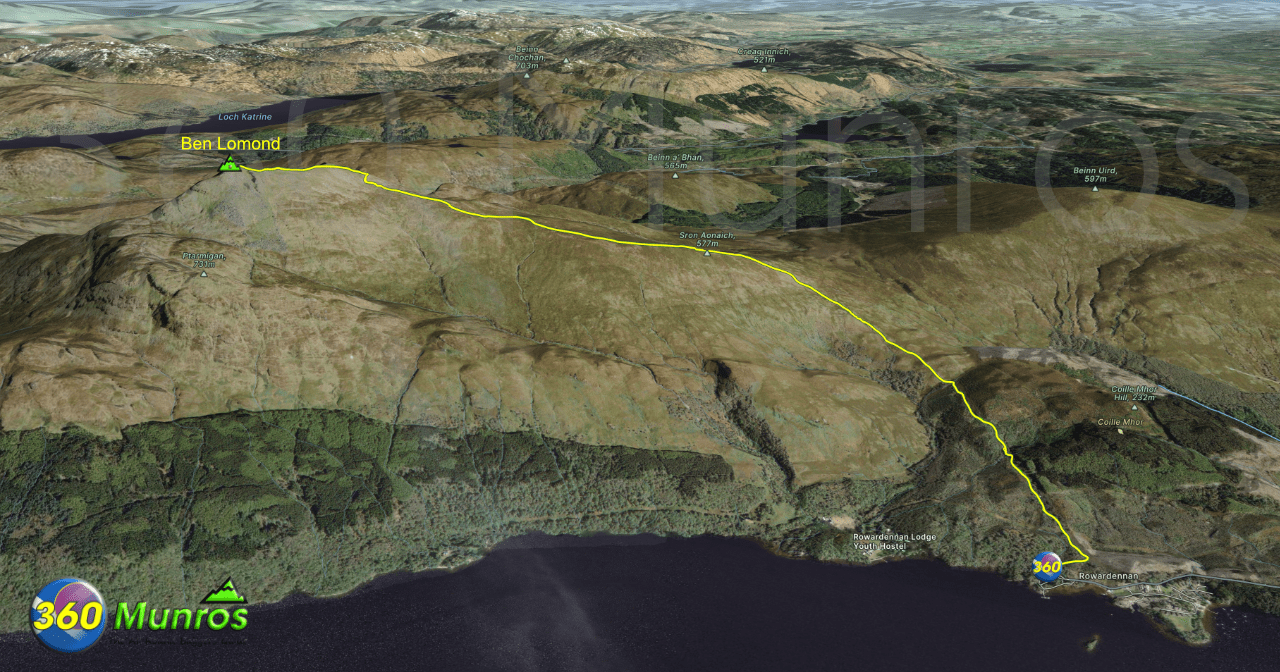
Length: 7.6 miles Total Ascent: 3090 ft Surface: Good Hikers Path
Difficulty: Moderate
Average Walking Time: 4:45 h
Route starts at the Ben Lomond Car Park, Stirling, Glasgow, G63 0AR.
Google maps directions to the route start can be found HERE
Ben Lomond
Mountain Path Route 360° Virtual Tour
Click on the round 360 logo in the tour window below to move forward through the Munro route tour. Pan Around using your mouse or finger. Press the Map - Show/Hide button to see where you are on the route. The red photo location marker within the map points it's radar in the direction of the photos view. The compass within the tour window lets you know the direction of view and travel. If possible view on a VR Headset to feel like your there!
Maps - View - Print - GPX File Download
All routes on 360munros.co.uk are SUMMER Munro Bagging Routes.
Winter Munro routes with Ice/Snow can be extremely challenging and dangerous.
The downloading and use of GPX files or printing of maps from 360munros.co.uk by individuals or groups as a navigational aid is entirely at the risk of the user.
Sunny Ptarmigan Adventure
From Rowardennan, under skies so clear,
We set off in laughter, full of cheer.
“Let’s climb via Ptarmigan, the airy route’s best!”
Someone’s forgetting, this ways a slightly bigger test.
Through sun draped woods, we skip and stride,
With Loch Lomond gleaming, a jewel at our side.
The air is crisp, and the mood is bright,
Today is gonna give us, pure hikers delight.
The trees fall away, and the ridge comes near,
“Just look at that view!” we all stop to cheer.
To the Arrochar Alp hills, our gaze takes flight,
Their jagged peaks bathed in a golden sun light.
Up through the hillside, we puff and climb,
Our jokes don’t stop, they pass the time.
This Ptarmigan route feels so wild and free,
It’s crags and cliffs and the odd bit scree.
On we scramble with the summit in sight,
Each step brings us closer to dizzying height.
Views of Scotland rolling vast and grand,
Mountains forever in this magic land.
Ben Lomond’s crown, eventually won,
It’s grandeur basking in the midday sun.
The loch sparkles bright, the other peaks gleam,
It’s a postcard view, a perfect dream.
We sit and snack with a satisfied cheer,
“Views like this deserve more than one beer!”
We can’t stay forever, so reluctantly push on,
Happily whistling together, we merrily march along.
Back to Rowardennan, our hearts still soar,
With tales to retell of this hill we now adore.
Ben Lomond you welcomed us, so mighty and calm,
A hike to remember, full of fun and charm.
©️David Clark
Ben Lomond Via Ptarmigan Ridge
A great route for the more experienced Munro Bagger is to take a nice ridge walk and scramble up over the Ptarmigan Ridge to the summit of Ben Lomond then enjoy the descent back down the mountain path.

Length: 7.5 miles Total Ascent: 3150 ft Surface: Rough Path
Difficulty: Moderate/Hard/Some easy scrambling
Average Walking Time: 5:00 h
Route starts at the Ben Lomond Car Park, Stirling, Glasgow, G63 0AR.
Google maps directions to the route start can be found HERE
Ptarmigan Path Winter 360° Virtual Tour
Click on the round 360 logo in the tour window below to move forward through the Munro route tour. Pan Around using your mouse or finger. Press the Map - Show/Hide button to see where you are on the route. The red photo location marker within the map points it's radar in the direction of the photos view. The compass within the tour window lets you know the direction of view and travel. If possible view on a VR Headset to feel like your there!
Maps - View - Print - GPX File Download
All routes on 360munros.co.uk are SUMMER Munro Bagging Routes.
Winter Munro routes with Ice/Snow can be extremely challenging and dangerous.
The downloading and use of GPX files or printing of maps from 360munros.co.uk by individuals or groups as a navigational aid is entirely at the risk of the user.
3D Model of Ben Lomond
3D model loading…… Internet speed dependant.
The red line on the 3D model shows the route.
Click on the 3D model to move around / zoom in out.
