Braeriach, Sgor an Lochain Uaine & Cairn Toul
These Munros are located quite deep in the Cairngorm Mountains and are great for those long summer day walks.
As with most Munros, there are different combinations of routes available. Below are routes we have done in the past.
The routes below approach from the Aviemore side to the North but can equally be walked from the Linn of Dee from the South.
Route 1
Out and Back
This is an out and back route from the sugarbowl car park through the Chalamain Gap into the Lairig Ghru. From here it climbs steeply up onto Braeriach, follow the corrie round to Sgor an Lochain Uaine then onto Cairn Toul. Return the same route.
Munro – Braeriach – Altitude: 1296 metres
Munro – Sgor an Lochain Uaine – Altitude: 1258 metres
Munro – Cairn Toul – Altitude: 1291 metres
Route Length: 20 miles Total Ascent: 5851 ft Surface: Rough/paths/boulders
Difficulty: Very Hard
Average Walking Time: 10:45 h
OS Map View Print HERE
Route starts at the Sugarbowl Car Park, Aviemore PH22 1RB.
Google maps directions to the route start can be found HERE
Route 2
Angel's Ridge
Again starting from the Sugarbowl car park. This route is probably more suited to the Munro Bagger with experience of rough steep ground as it involves a scramble up Angel’s Ridge.
Munro – Braeriach – Altitude: 1296 metres
Munro – Sgor an Lochain Uaine – Altitude: 1258 metres
Munro – Cairn Toul – Altitude: 1291 metres
Route Length: 19 miles Total Ascent: 5302 ft Surface: Rough/paths/boulders
Difficulty: Very Hard
Average Walking Time: 10:10 h
OS Map View Print HERE
Route starts at the Sugarbowl Car Park, Aviemore PH22 1RB.
Google maps directions to the route start can be found HERE
Route 3
Devil's Point
Again starting from the Sugarbowl car park. This route is probably more suited to the very fit Munro Baggers who wants to include a climb up the extra Munro – Devil’s Point .
Munro – Braeriach – Altitude: 1296 metres
Munro – Sgor an Lochain Uaine – Altitude: 1258 metres
Munro – Cairn Toul – Altitude: 1291 metres
Munro – The Devil’s Point – Altitude: 1004 metres
Route Length: 22 miles Total Ascent: 5725 ft Surface: Rough/paths/boulders
Difficulty: Very Hard
Average Walking Time: 11:45 h
OS Map View Print HERE
Route starts at the Sugarbowl Car Park, Aviemore PH22 1RB.
Google maps directions to the route start can be found HERE
Cairngorm 4000's - 360° Virtual Tour
360 Photos of Braeriach, Sgor an Lochain Uaine & Cairn Toul can be seen on the virtual tour below.
The Cairngorm 4000 route details can be viewed HERE.
Click on the round 360 logo in the tour window below to move forward through the Munro route tour. Pan Around using your mouse or finger. Press the Map - Show/Hide button to see where you are on the route. The red photo location marker within the map points it's radar in the direction of the photos view. The compass within the tour window lets you know the direction of view and travel. If possible view on a VR Headset to feel like your there!
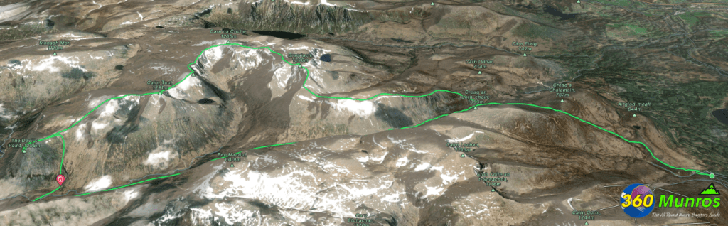
3D Model of Braeriach, Sgor an Lochain Uaine & Cairn Toul
3D model loading…… Internet speed dependant.
The red line on the 3D model shows the Angel’s Ridge route.
Click on the 3D model to move around / zoom in out.
