Crainlarich 5 Munros
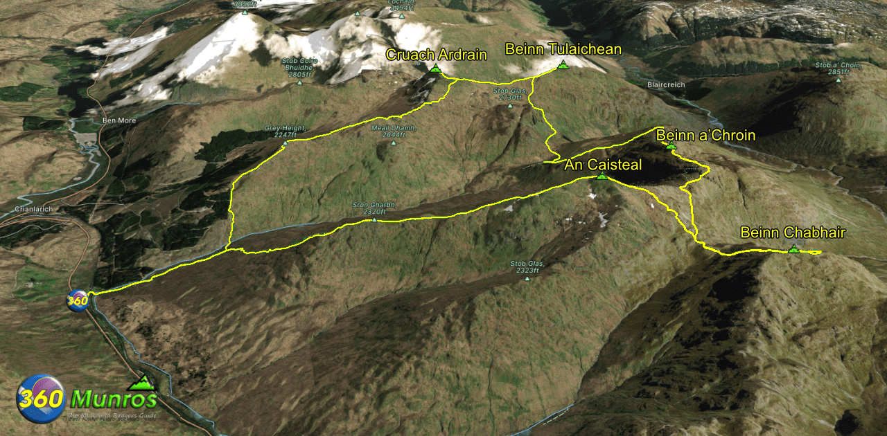
From the shapely ridges of Cruach Ardrain and Beinn Tulaichean to the rocky drama of An Caisteal and Beinn a’ Chroin, with the wild isolation of Beinn Chabhair, this cluster offers variety, challenge, and some of the finest views in the Southern Highlands.
Route details with map, 3D model and GPX download of the route to the summit of these mountains in Scotland.
Munro – Cruach Ardrain – Altitude: 1046 metres
Munro – Beinn Tulaichean – Altitude: 946 metres
Munro – Beinn a’Chroin – Altitude: 940 metres
Munro – Beinn Chabhair – Altitude: 933 metres
Munro – An Caisteal – Altitude: 995 metres
Length: 15 miles Total Ascent: 7200 ft
Surface: Rough/pathless sections/some easy scrambling/good navigation skills required
Difficulty: Very Hard
Average Walking Time: 11:00 h
Route starts at the A82 Car Park, Crianlarich FK20 8RL.
Google maps directions to the route start can be found HERE
Crainlarich 5 - 360° Virtual Tour
Click on the round 360 logo in the tour window below to move forward through the Munro route tour. Pan Around using your mouse or finger. Press the Map - Show/Hide button to see where you are on the route. The red photo location marker within the map points it's radar in the direction of the photos view. The compass within the tour window lets you know the direction of view and travel. If possible view on a VR Headset to feel like your there!
Maps - View - Print - GPX File Download
All routes on 360munros.co.uk are SUMMER Munro Bagging Routes.
Winter Munro routes with Ice/Snow can be extremely challenging and dangerous.
The downloading and use of GPX files or printing of maps from 360munros.co.uk by individuals or groups as a navigational aid is entirely at the risk of the user.
3D Model of Crainlarich 5 Munros
3D model loading…… Internet speed dependant.
The red line on the 3D model shows the route.
Click on the 3D model to move around / zoom in out.
