The Mamores
The main backbone of the Mamores stretches from Meall a’ Chaorainn, a subsidiary top of Mullach nan Coirean, at the western end of the ridge, to Sgòr Eilde Beag, a top of Binnein Mòr some 10 km to the east. Three narrow arêtes run north from the main ridge connecting to the summits of Sgurr a’ Mhàim, An Gearanach and Binnein Mòr. Beyond the eastern end of the ridge are two steep outlying peaks: Binnein Beag and Sgurr Eilde Mòr. Sandwiched between the remote upper section of Glen Nevis, and Lochs Eilde Mòr and Eilde Beag, these two peaks are the remotest in the Mamores.
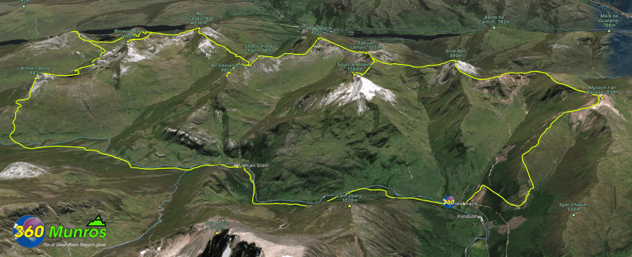
Route details with 360° virtual tour, map, 3D model and GPX download of the route to the summit of these mountains in Scotland.
Mullach nan Coirean – (‘Summit of the Corries’) – Altitude: 939 m
Stob Bàn – (‘White Peak’) – Altitude: 999 m
Sgurr a’ Mhàim – (‘Peak of the Large Rounded Hill’) – Altitude: 1099 m
Am Bodach – (‘The Old Man’) – Altitude: 1032 m
Stob Coire a’ Chàirn – (‘Peak of the Corrie of the Cairn’) – Altitude: 981 m
An Gearanach – ( ‘Short Sharp Ridge’) – Altitude: 982 m
Na Gruagaichean – (‘The Maidens’) – Altitude: 1056 m
Binnein Mòr – (‘Big Mountain’) – Altitude: 1130 m
Sgurr Eilde Mòr – (‘Big Peak of the Hind’) – Altitude: 1010 m
Binnein Beag – (‘Small Peak’) – Altitude: 943 m
Route Length: 23 miles Total Ascent: 9870 ft Surface: Rough/paths
Difficulty: Very Hard.
Average Walking Time: 14:45 h
This is a big day out, ideal for an overnight camp.
The north descent from Binnein Beag is very steep through a boulder field, this can be avoided by
doubling back down and follow the path to the west then north of the hill at around 750m .
Route starts at Achriabhach in Glen Nevis, Fort William, PH33 6SY
Google maps directions to the route start can be found HERE
Mamores
360° Virtual Tour
The virtual tour photos start on the dirt track a couple of kilometers up the hill from Achriabhach.
Click on the round 360 logo in the tour window below to move forward through the Munro route tour. Pan Around using your mouse or finger. Press the Map - Show/Hide button to see where you are on the route. The red photo location marker within the map points it's radar in the direction of the photos view. The compass within the tour window lets you know the direction of view and travel. If possible view on a VR Headset to feel like your there!
Maps - View - Print - GPX File Download
All routes on 360munros.co.uk are SUMMER Munro Bagging Routes.
Winter Munro routes with Ice/Snow can be extremely challenging and dangerous.
The downloading and use of GPX files or printing of maps from 360munros.co.uk by individuals or groups as a navigational aid is entirely at the risk of the user.
3D Model of the Mamores
3D model loading…… Internet speed dependant.
The red line on the model shows the route.
Click on the 3D model to move around / zoom in out.
