Sgiath Chùil & Meall Glas
‘Back Wing’ & ‘Greenish-Grey Hill’
Sgiath Chùil – “Back Wing” In Gaelic lore, wings often symbolise protection and flight. Sgiath Chùil, the back wing, can be imagined as a guardian ridge, sheltering Glen Lochay behind its broad slopes. Its name evokes the image of a great bird poised to take flight, reminding walkers that even gentle hills can carry a sense of watchfulness and quiet strength.
Meall Glas – “Green Hill” The green hill reflects renewal and growth, its rounded summit echoing the cycles of the land. In folklore, green hills were places of fertility and abundance, where the earth itself seemed to breathe with life. Meall Glas embodies this spirit, offering a calm, nurturing presence above Glen Dochart, a counterpoint to the sharper ridges nearby.
Sgiath Chùil & Meall Glas Together, the back wing and the green hill form a natural pairing: one a guardian, the other a symbol of renewal. Climbed side by side, they invite walkers to see not just the landscape, but the living spirit of Breadalbane woven into its hills.
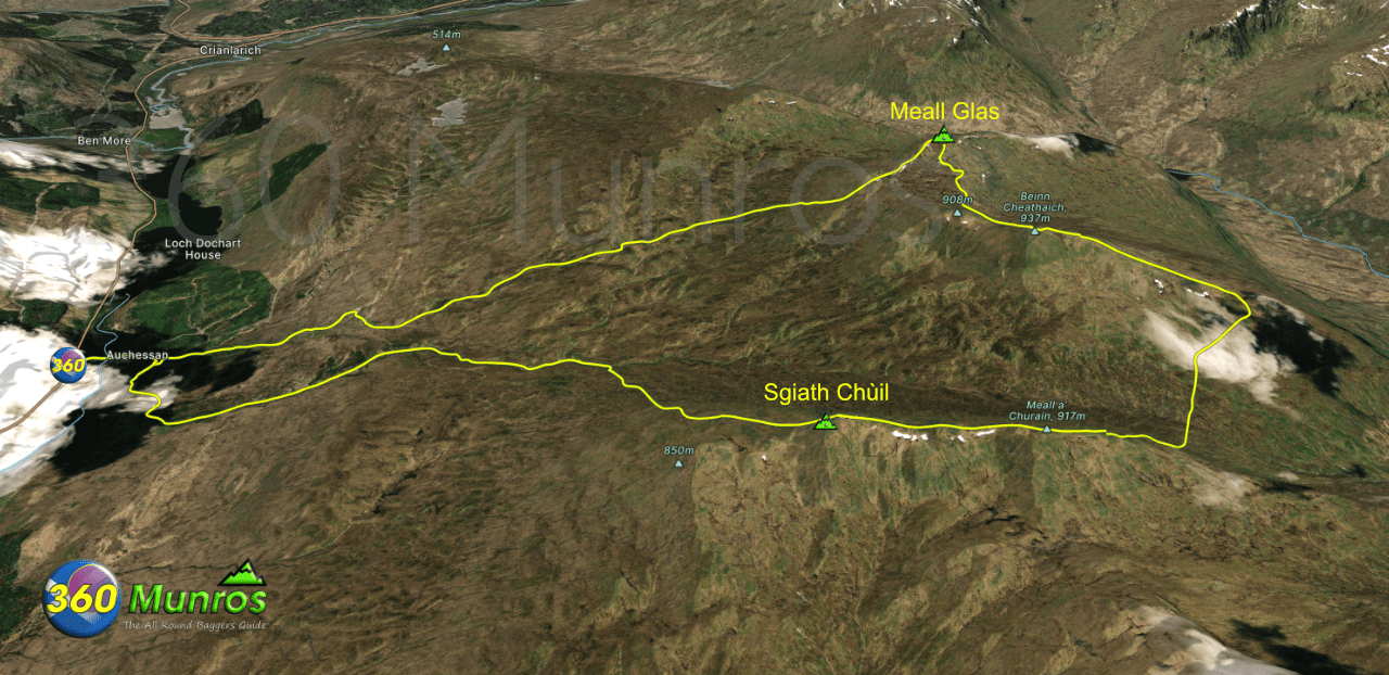
Route details, virtual tour with map, 3D model and GPX download of the route to the summit of these mountains in Scotland.
Munro – Sgiath Chùil – Altitude: 921 metres
Munro – Meall Glas – Altitude: 959 metres
Route Length: 10.7 miles Total Ascent: 4000 ft Surface: Paths/Pathless/Bog/Heather
Difficulty: Moderate/Hard
Average Walking Time: 6:30 h
This route avoids the steep descent from Sgiath Chùil into Lairig a Churain. Instead it descends on a slightly easier gradient north west to pick up the walkers route from Glen Lochay.
Although shown on some maps, the path from Meall Glas is pretty faint and non existent in places – See virtual tour below.
This route starts on the A85 at the driveway to Auchessan farm just south of Crianlarich FK20 8QS.
Google maps directions HERE
Sgiath Chùil & Meall Glas
360° Virtual Tour
Click on the round 360 logo in the tour window below to move forward through the Munro route tour. Pan Around using your mouse or finger. Press the Map - Show/Hide button to see where you are on the route. The red photo location marker within the map points it's radar in the direction of the photos view. The compass within the tour window lets you know the direction of view and travel. If possible view on a VR Headset to feel like your there!
Maps - View - Print - GPX File Download
All routes on 360munros.co.uk are SUMMER Munro Bagging Routes.
Winter Munro routes with Ice/Snow can be extremely challenging and dangerous.
The downloading and use of GPX files or printing of maps from 360munros.co.uk by individuals or groups as a navigational aid is entirely at the risk of the user.
3D Model of Sgiath Chùil & Meall Glas
3D model loading…… Internet speed dependant.
The red line on the 3D model shows the route.
Click on the 3D model to move around / zoom in out.
