Sgùrr Mòr
‘Big Peak’
Route details with map, 3D model and GPX download of the route to the summit of these mountains in Scotland.
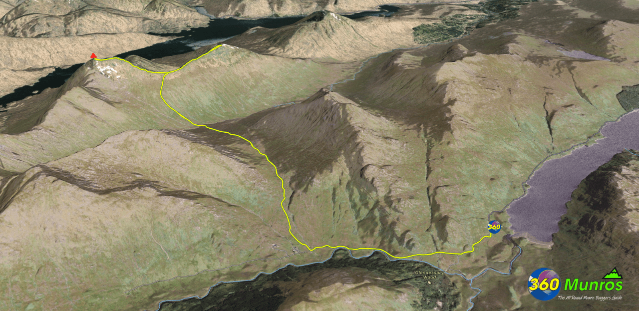
Sgùrr Mòr – Munro – Altitude: 1003 metres
Sgùrr an Fhuarain – Corbett – Altitude: 901 metres
Length: 13.2 miles Total Ascent: 4860 ft Surface: Rough/steep/pathless
Difficulty: Hard
Route starts from a small car park east of Strathan, Spean Bridge, PH33 7NP.
Google maps directions to the route start can be found HERE
Sgùrr Mòr and Sgùrr an Fhuarain
360° Virtual Tour
Click on the round 360 logo in the tour window below to move forward through the Munro route tour. Pan Around using your mouse or finger. Press the Map - Show/Hide button to see where you are on the route. The red photo location marker within the map points it's radar in the direction of the photos view. The compass within the tour window lets you know the direction of view and travel. If possible view on a VR Headset to feel like your there!
The virtual tour route above starts just before Stalkers Cottage. See the virtual tour below for route photos from the Loch Askaig car park.
Maps - View - Print - GPX File Download
3D Model of Sgùrr Mòr and Sgùrr an Fhuarain
3D model loading…… Internet speed dependant.
Click on the 3D model to move around / zoom in out.
Sgùrr nan Coireachan, Garbh Chioch Mhòr, Sgùrr na Cìche & Sgùrr Mòr

This route has the same start point and takes in 3 extra Munros.
Munro – Sgùrr nan Coireachan – Altitude: 953 metres
Munro – Garbh Chioch Mhòr – Altitude: 1013 metres
Munro – Sgùrr na Cìche – Altitude: 1040 metres
Munro – Sgùrr Mòr – Altitude: 1003 metres
Length: 18.5 miles Total Ascent: 6700 ft Surface: Rough
Difficulty: Very Hard
Average Walking Time: 11:30 h
Route starts at the car park west of Loch Arkaig.
Google maps directions to the route start can be found HERE
Sgùrr nan Coireachan, Garbh Chioch Mhòr, Sgùrr na Cìche
360° Virtual Tour
Click on the round 360 logo in the tour window below to move forward through the Munro route tour. Pan Around using your mouse or finger. Press the Map - Show/Hide button to see where you are on the route. The red photo location marker within the map points it's radar in the direction of the photos view. The compass within the tour window lets you know the direction of view and travel. If possible view on a VR Headset to feel like your there!
Maps - View - Print - GPX File Download
All routes on 360munros.co.uk are SUMMER Munro Bagging Routes.
Winter Munro routes with Ice/Snow can be extremely challenging and dangerous.
The downloading and use of GPX files or printing of maps from 360munros.co.uk by individuals or groups as a navigational aid is entirely at the risk of the user.
