The 7 South Glen Shiel Ridge Munros
Seven Munros linked by one continuous high‑level traverse: from Creag a’ Mhàim in the east to Creag nan Dàmh in the west. This epic ridge walk combines grassy slopes, rocky crests, and panoramic views across Kintail, Knoydart, and Skye — a true Highland classic.
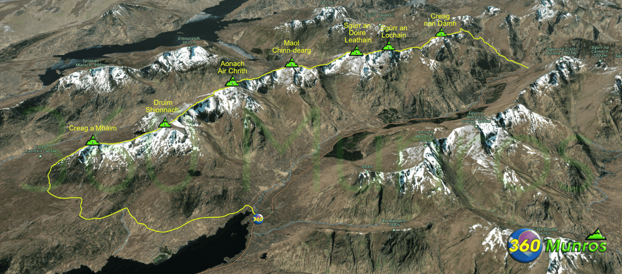
Route details with map, 3D model and GPX download of the route to the summits of these mountains in Kintail, Scotland.
Munro – Creag a’Mhàim – Altitude: 947 metres
Munro – Druim Shionnach – Altitude: 987 metres
Munro – Aonach Air Chrith – Altitude: 1021 metres
Munro – Maol chinn-dearg – Altitude: 981 metres
Munro – Sgùrr an Doire Leathain – Altitude: 1010 metres
Munro – Sgùrr an Lochain – Altitude: 1004 metres
Munro -Creag nan Dàmh – Altitude: 918 metres
Route Length: 16 miles Total Ascent: 5200 ft Surface: Road/Paths/Grass
Difficulty: Hard
Average Walking Time: 11:15 h
Route starts next to the Cluanie Inn.
Google maps directions to the route start can be found HERE
The 7 South Glen Shiel Ridge Munros
360° Virtual Tour
Click on the round 360 logo in the tour window below to move forward through the Munro route tour. Pan Around using your mouse or finger. Press the Map - Show/Hide button to see where you are on the route. The red photo location marker within the map points it's radar in the direction of the photos view. The compass within the tour window lets you know the direction of view and travel. If possible view on a VR Headset to feel like your there!
Maps - View - Print - GPX File Download
All routes on 360munros.co.uk are SUMMER Munro Bagging Routes.
Winter Munro routes with Ice/Snow can be extremely challenging and dangerous.
The downloading and use of GPX files or printing of maps from 360munros.co.uk by individuals or groups as a navigational aid is entirely at the risk of the user.
3D Model of The 7 South Glen Shiel Ridge Munros
3D model loading…… Internet speed dependant.
The red line on the 3D model shows the route.
Click on the 3D model to move around / zoom in out.
