Beinn Ime & Beinn Narnain
‘Butter Mountain’ & ‘Hill of Notches’
At the head of Loch Long, the Arrochar Alps rise high in the Loch Lomond & Trossachs National Park. This compact cluster of rugged peaks has long been a favourite of walkers and climbers, offering variety, drama, and sweeping views within a single day’s outing. The jagged profile of The Cobbler (Ben Arthur) is the most iconic, its rocky summit resembling a craftsman at work and drawing countless visitors to scramble its pinnacle. Beyond it, the high dome of Beinn Ime, the Butter Mountain, stands as the tallest of the group, broad and commanding at over 1000 metres. Beside it lies Beinn Narnain, the Hill of Notches, steep and scarred with crags and gullies, a rugged contrast to Ime’s smoother slopes.
Together, these mountains form a natural amphitheatre above Arrochar, combining rocky drama with grassy ridges and panoramic views across Loch Lomond, the Firth of Clyde, and deep into the Highlands. Whether climbed individually or linked in a longer circuit, the Arrochar Alps embody both accessibility and adventure — a perfect introduction to Munro bagging and a reminder of the wild spirit that begins where the lowlands end.
Route details with map, 3D model and GPX download of the route to the summit of these mountains in Scotland.
Corbett – The Cobbler – Altitude: 884 metres
Munro – Beinn Ime – Altitude: 1011 metres
Munro – Beinn Narnain – Altitude: 926 metres
Route Length: 10 miles Total Ascent: 5000 ft Surface: Rough/paths
Difficulty: Hard/Steep climbs
Average Walking Time: 6:50 h
Plenty of parking at Loch Long car park. Directions with Google maps HERE
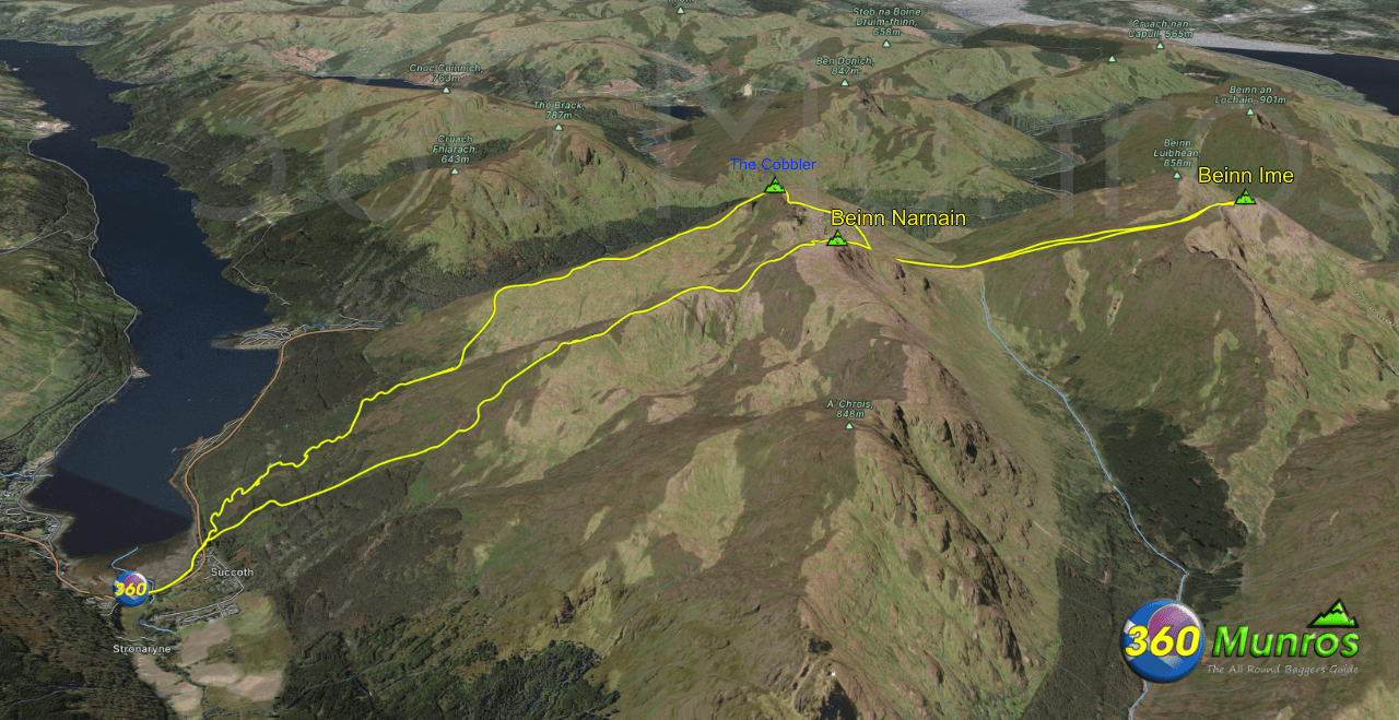
This route climbs the steep zig zags to the Corbett – The Cobbler or ‘Ben Arthur’ as it’s named by some, before heading out to the 1st Munro Beinn Ime then returning via Munro Beinn Narnain.
There are plenty of car parking spaces at Loch Long car park.
Beware – this car park is operated by a private firm, they have number plate recognition cameras. You will get fined if you don’t pay or stay over your paid for time.
Fancy all the Arrochar Munros in one route?
360° Virtual Tour of Beinn Ime & Beinn Narnain Munros can be found on the Arrochar Alps Munro Route HERE
Maps - View - Print - GPX File Download
The map below shows the route to these mountains - Beinn Ime & Beinn Narnain via the Cobbler. There is a gpx file download available under the map.
All routes on 360munros.co.uk are SUMMER Munro Bagging Routes.
Winter Munro routes with Ice/Snow can be extremely challenging and dangerous.
The downloading and use of GPX files or printing of maps from 360munros.co.uk by individuals or groups as a navigational aid is entirely at the risk of the user.
3D Model of the The Cobbler, Beinn Ime, Beinn Narnain
3D model loading…… Internet speed dependant.
The red line on the 3D model shows the route.
Click on the 3D model to move around / zoom in out.
